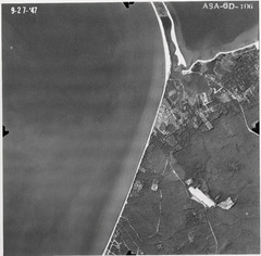
sc9_27_47 6D 106
sc9_27_47 6D 106
| dc.date.accessioned | 2021-08-14T17:44:56Z | |
| dc.date.available | 2021-08-14T17:44:56Z | |
| dc.identifier.uri | http://hdl.handle.net/11401/89465 | |
| dc.subject | Long Island (N.Y.) - History - Aerial Imagery. | |
| dc.title | sc9_27_47 6D 106 | |
| dcterms.creator | United States, Department of Agriculture | |
| dcterms.dateAccepted | 2012-10-25 | |
| dcterms.description | Aerial(s) Local Government Zoning | |
| dcterms.extent | 24cm X 24cm | |
| dcterms.identifier | sc9_27_47 6D 106.jpg | |
| dcterms.identifier | 264.jp2 | |
| dcterms.isPartOf | Maps Collection, Stony Brook University Libraries | |
| dcterms.issued | 1947-09-23 | |
| dcterms.modified | 2014-06-18 | |
| dcterms.provenance | The 1947 aerial photos were scanned by Fred Mushacke. The photos were borrowed from the Suffolk County Soil and Water Conservation District. The photos were scanned at 600 dpi and saved as *.jpg files. The photos were scanned in August and September 2003. An index map was not available at the time of scanning and the photos are random shots of the west end of Suffolk County (Nassau County line- Millerplace/Patchogue. PhotoIndexing is as follows: sc 19xx and unique photo id#. These photos comprise the tidal areas of the 1947 photo set. | |
| dcterms.provenance | 1 | |
| dcterms.provenance | 14124144 | |
| dcterms.provenance | 13.47 MB | |
| dcterms.spatial | Suffolk County, 1947 | |
| dcterms.spatial | PMA-1:20000 | |
| dcterms.subject | Long Island (N.Y.) - History - Aerial Imagery. | |
| dcterms.title | sc9_27_47 6D 106 | |
| dcterms.type | Image |

