S-30-3
S-30-3
| dc.date.accessioned | 2021-08-17T07:12:46Z | |
| dc.date.available | 2021-08-17T07:12:46Z | |
| dc.identifier.uri | http://hdl.handle.net/11401/92836 | |
| dc.title | S-30-3 | |
| dcterms.creator | N/A | |
| dcterms.dateAccepted | 2014-06-18 | |
| dcterms.description | N/A | |
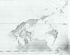
| dcterms.description | 1773 Hand Map Shelter Island Bathymetry | |
| dcterms.description | 1773 hand drawn map of Shelter Island and Gardner's Island. Numbers on water might indicate bathymetric data | |
| dcterms.description | Knot direction and magnitude labeled with arrows. Hand writing in bottom right corner 'G 3802.L6' 1775-1783' | |
| dcterms.identifier | ShelterIs1773.tif | |
| dcterms.issued | 1773 | |
| dcterms.language | en | |
| dcterms.rights | Campus Only | |
| dcterms.title | S-30-3 | |
| dcterms.type | Image |