S-2-4
S-2-4
| dc.date.accessioned | 2021-08-17T07:13:08Z | |
| dc.date.available | 2021-08-17T07:13:08Z | |
| dc.identifier.uri | http://hdl.handle.net/11401/92851 | |
| dc.title | S-2-4 | |
| dcterms.creator | Ferdinand Rudolph Hassler Sup. | |
| dcterms.dateAccepted | 2014-06-18 | |
| dcterms.description | United States Coast Survey | |
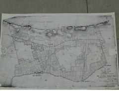
| dcterms.description | 1838 US Coast Survey Old Landing | |
| dcterms.description | 1838 US Coast Survey of Old Landing to Coopers Hills. | |
| dcterms.description | Hand drawn map showing shoreline, roads, and property grids | |
| dcterms.identifier | T-54.jpg | |
| dcterms.issued | 1838 | |
| dcterms.language | en | |
| dcterms.rights | Campus Only | |
| dcterms.title | S-2-4 | |
| dcterms.type | Image |