S-20-5
S-20-5
| dc.date.accessioned | 2021-08-17T07:21:37Z | |
| dc.date.available | 2021-08-17T07:21:37Z | |
| dc.identifier.uri | http://hdl.handle.net/11401/92861 | |
| dc.title | S-20-5 | |
| dcterms.dateAccepted | 2014-06-05 | |
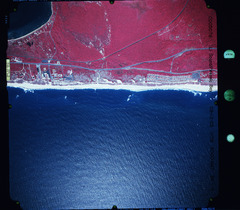
| dcterms.description | 2005 Infrared Aerial Hither Hills Montauk Hwy | |
| dcterms.description | High resolutiuon infrared aerial image of Hither Hills and Montauk Highway | |
| dcterms.description | Plane gauges located in right margin | |
| dcterms.identifier | Walking-dune_36-4 | |
| dcterms.issued | 9/12/2005 | |
| dcterms.modified | 2014-06-16 | |
| dcterms.rights | Campus Only | |
| dcterms.title | S-20-5 |