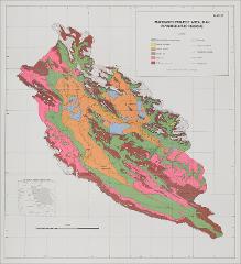
The physical geography, geomorphology, and Late Quaternary history of the Mahidasht project area, Qara Su Basin, central west Iran ; Map
The physical geography, geomorphology, and Late Quaternary history of the Mahidasht project area, Qara Su Basin, central west Iran ; Map
| dc.date.accessioned | 2021-08-14T05:43:41Z | |
| dc.date.available | 2021-08-14T05:43:41Z | |
| dc.identifier.uri | http://hdl.handle.net/11401/88987 | |
| dc.subject | Geology, Stratigraphic -- Holocene - Geology -- Iran -- Kirmanshah Region - Physical geography -- Iran -- Kirmanshah Region | |
| dc.title | The physical geography, geomorphology, and Late Quaternary history of the Mahidasht project area, Qara Su Basin, central west Iran ; Map | |
| dcterms.dateAccepted | 2011-06-21 | |
| dcterms.isPartOf | AMAR | |
| dcterms.language | eng | |
| dcterms.modified | 2011-06-28 | |
| dcterms.provenance | 2010 | |
| dcterms.provenance | Digitized by the Schoenberg Center for Electronic Text and Image at the University of Pennsylvania for the AMAR Collection. | |
| dcterms.provenance | This does not have the proper title and we need the page by page access. KD:6/21/11 this was originally a test upload. Replaced it with correct file and metadata. This map belongs with The physical geography, geomorphology, and Late Quaternary history of the Mahidasht project area, Qara Su Basin, central west Iran text. | |
| dcterms.rights | May not be reused for commercial purposes. | |
| dcterms.spatial | Mahidasht | |
| dcterms.subject | Geology, Stratigraphic -- Holocene | |
| dcterms.subject | Geology -- Iran -- Kirmanshah Region | |
| dcterms.subject | Physical geography -- Iran -- Kirmanshah Region | |
| dcterms.title | The physical geography, geomorphology, and Late Quaternary history of the Mahidasht project area, Qara Su Basin, central west Iran ; Map |